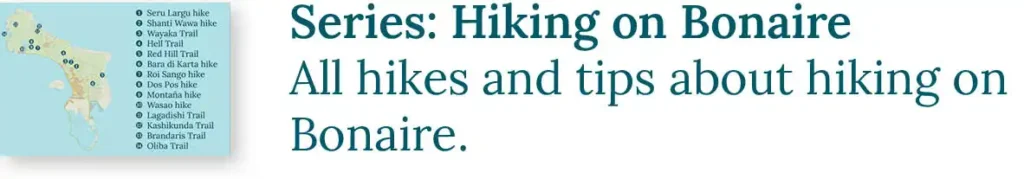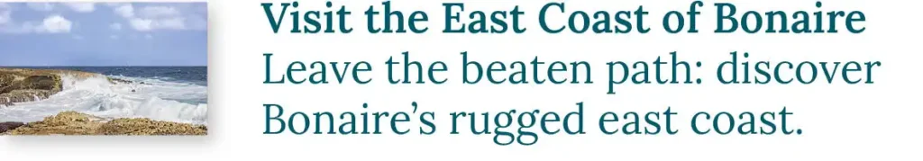

Exploring Bonaire on foot truly brings the island to life. Hiking brings you closer to nature and the landscape, reveals hidden spots, and allows you to enjoy birdsong and other sounds often lost while driving. A hike offers an intimate encounter with Bonaire: pause to admire a fluttering butterfly, soak in the expansive views, and take the time and space to fully embrace the moment. A walk is a must during your vacation on Bonaire! We’ve compiled a list of the ten most beautiful hikes on Bonaire, complete with starting points and other useful details.
Sharing Island Love
Thank you for your interest in our beautiful island in the Caribbean! We love sharing our passion for Bonaire with everyone — locals, visitors, and of course, with our guests during Our tours. Curious how we do that? You can find all the details in Sharing Island Love.
With Island Love,![]()
With proper preparation, you can enjoy all these hikes independently. Be sure to check out our helpful hiking tips and learn about the Nature on Bonaire. Want to make the most of your walk? Book a customized hiking tour with us. Immerse yourself in fascinating nature, uncover traces of the past, and return home with stunning photos. And since we only offer private tours, you can walk at your own pace and without a care in the world!
Onderwerpen
Explanation of trails and rating
Three types of trails:

Difficulty rating:
* Walk on accessible, flat terrain.
** Walk on accessible, gently sloping terrain or uneven ground.
*** Walk on sloping terrain.
**** Walk on sloping terrain, with occasional short climbs.
***** Challenging walk on steep terrain, requiring frequent climbing.
The length of the walk is not taken into account when determining the difficulty level.
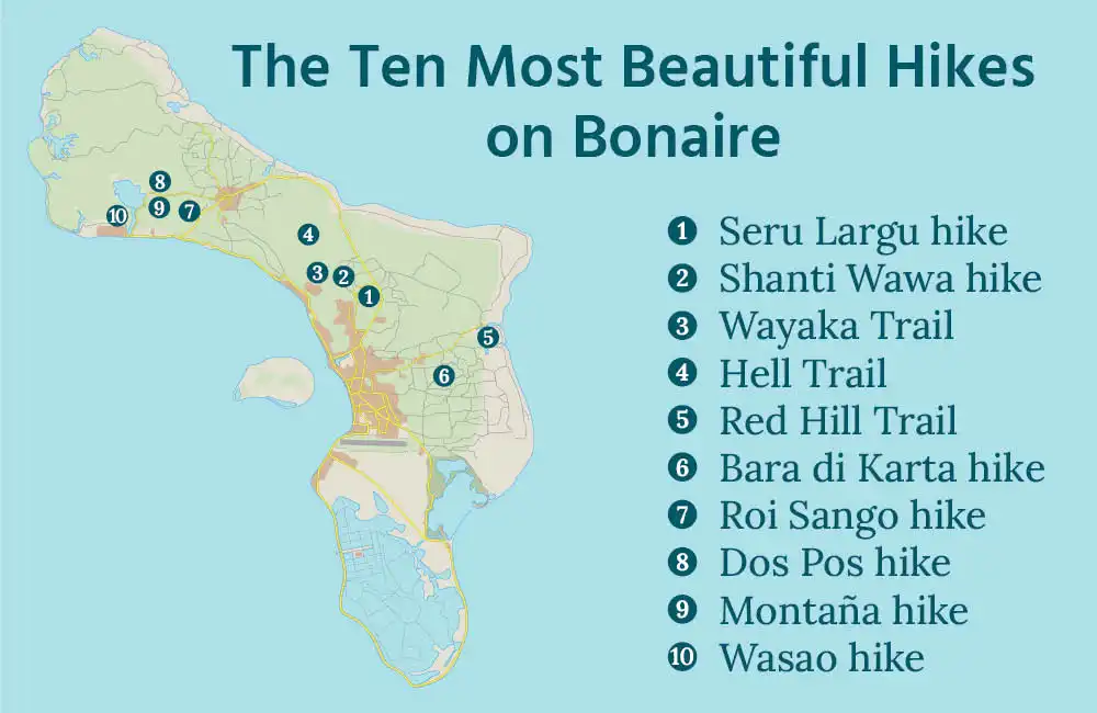
1. Seru Largu Hike

At Bonaire’s most famous viewpoint, the Seru Largu, a beautiful hike has been set up. The trail offers stunning views of the southern and eastern parts of Bonaire. The terrain is flat, and along the way, you can spot many colorful birds resting in the trees, such as the prikichi.

Practical information
Difficulty: *
Length: 3 km (2 miles), out-and-back trail, with a short loop
Starting point along the paved road.
Can be combined with: Shanti Wawa hike and the Scenic Drive to the North
This very accessible walk starts 80 meters (250 feet) north of the Millennium Monument, the viewpoint with the large cross, and is marked with pink stones.
2. Shanti Wawa hike

North of Seru Largu, there is a relatively unknown but enjoyable hike to the Shanti Wawa viewpoint. It’s a short hike, but with a challenging climb towards the end. At the viewpoint, you have stunning views over the East Coast of Bonaire.

Practical information
Difficulty: ****
Length: 1 km (0.6 miles), out-and-back trail
Starting point along an unpaved road.
Can be combined with: Seru Largu hike and the Scenic Drive to the North
The starting point of this hike is located along an unpaved road in Bonaire’s kunuku, 300 meters (1000 feet) from Aletta’s Goat Farm and 2 km (1.25 miles) from the Millennium Monument on the Seru Largu.
Text continues below…

3. Wayaka Trail

If you’re looking for a good hike on Bonaire, we recommend the Wayaka Trail. The path winds through the island’s rugged nature. Along the way, you encounter ancient trees and unique orchids, and you also have the chance to admire many birds. The trail is 7.46 miles long (out-and-back), but of course, you can choose to turn back earlier and cover a shorter distance.

Practical information
Difficulty: **
Length: up to 12 km (7.5 miles), out-and-back trail
Starting point along a paved road.
Can be combined with: Hell Trail and the Scenic Drive to the North
The trail begins at the top of the Sabadeco Terrace neighborhood and mostly follows flat terrain. To reach the start of the trail, enter the narrow path at the starting point. After 400 meters (a quarter mile), turn left at the T-junction. Another 400 meters ahead, you will find the trail’s starting point marked with a sign.
At the end of the Wayaka Trail, you will reach a T-junction—this is the Hell Trail. If you turn left, after just over 2 km (1.2 miles), you arrive at the unpaved Kaminda Broertje Janga. Turning right will lead you to Porta Spaño, near Landsailing, at the main road between Rincon and Kralendijk, also about 2 km (1.2 miles) away.
4. Hell Trail

The Hell Trail (Ruta Dos Laman in het Papiamentu) is a long hiking path that crosses Bonaire from west to east. The route takes you through the beautiful Nature of Bonaire, offering breathtaking views of both the west and east coasts. Along the way, you can visit the Tree Cave, a natural wonder featuring a tree growing within a cave. To find it, turn left onto a wide sand road after 600 meters (0.4 miles). Walk another 250 meters (800 feet) to reach the cave.

Practical information
Difficulty: ***
Length: 5 km (3 miles), point-to-point trail
Or: 10 km (6 miles) out-and-back
Starting point along an unpaved road.
End point along a paved road
Can be combined with: Wayaka Trail
The Hell Trail runs over a rocky surface, surrounded by tropical vegetation and cacti. The path is well-marked with blue stones. The trail is fairly challenging, as it climbs to the top of the hill, followed by a descent to the endpoint at Porta Spaño. Since the Hell Trail is a point-to-point hike, it’s important to arrange transportation for the return journey to the starting point. Alternatively, you can also turn around at the endpoint (or earlier) and walk back to the start.
5. Red Hill hike

At Plantation Washikemba, you find the Red Hill Hike (Ruta Washikemba in Papiamentu), which passes a hill (just 30 meters/100 feet high) made of reddish-brown rock, where a cactus forest grows. The first part of the route winds through this breathtaking landscape. But this hike has even more to offer. It also takes you past a small mangrove forest along the shores of Lagun, across an open coastal plain, and over Saliña Washikemba, where you can admire the Longest Tree of Bonaire. The Red Hill is even more stunning in the warm light of sunrise and sunset!

Practical information
Difficulty: **
Length: 3 km (2 miles), loop trail
Starting point along an unpaved road
Can be combined with: Bara di Karta hike
The Red Hill hike is well-marked with pink stones. The starting point is at a pink sign at the edge of the usually dry Saliña Washikemba. With a high-clearance vehicle, this point is usually accessible.
During the rainy season, the Saliña turns into a treacherous muddy flat, where cars often get stuck. By parking at the turnoff to Plantation House Washikemba, you can avoid such problems. This adds an additional one and a half kilometers (a mile) to the hike.
6. Bara di Karta hike

The Bara di Karta hike takes you to the top of a 55-meter/180-feet-high hill that rises from the otherwise flat landscape. A narrow path leads you upwards to this stunning viewpoint over the southern part of Bonaire and much of the East coast. The summit consists of large pieces of igneous rock, which emerged from the ocean depths around 70 million years ago. You can read more about this in The Geology of Bonaire.
The Shanti Wawa Hike is part of our Gems of the East Tour.

Practical information
Difficulty: ***
Length: 1 km (0.6 miles), out-and-back trail
Starting point along an unpaved road.
Can be combined with: Red Hill hike, the Scenic Drive to the Salt Pans, and Sorobon
You will find the start of the trail directly across from Pos Bara di Karta. It’s well-marked with pink stones. The ascent starts gradually but becomes steeper towards the end. You may even need to use your hands at times. Watch out for loose rocks that you could slip on and for the many tuna or Mickey Mouse cacti growing right along the trail. A slight touch and they cling to your leg.
7. Roi Sango Hike

East of Rincon, you find the Roi Sango Hike. This trail is relatively unknown, but it’s definitely worth doing! During this hike, you descend into the Sango Gorge, a unique spot with beautiful trees and impressive cliffs. Early in the morning, you can enjoy a real bird concert here.

Practical information
Difficulty: ***
Length: 2,5 km (1.5 miles), out-and-back trail
Starting point along a paved road.
Can be combined with: Dos Pos hike, Wasao hike, Montaña hike and the Scenic Drive to the North
The hike starts at the beginning of the unpaved road to Alta Mira Unjo, the viewpoint above Rincon. Walk left onto the wide path marked with pink stones. This path leads to the gate of the gorge. Be careful when descending into the gorge, as the loose stones on the path can make it slippery!
8. Dos Pos Hike

If you love beautiful vistas, the Dos Pos hike is highly recommended! The trail passes Lake Goto and around Seru Dos Pos, a 125-meter/400-feet-high hill north of the Dos Pos water well. You have fantastic views of the rolling landscape and Lake Goto. Along the way, you will be immersed in the nature of Bonaire. Who knows, you might spot a hummingbird flitting from flower to flower! As you walk, your eyes will feast on the scenery. This makes the Dos Pos hike one of the most popular hikes on Bonaire.

Practical information
Difficulty: ***
Length: 4 km (2.5 miles), loop trail
Starting point along a paved road.
Can be combined with: Montaña hike, Wasao hike, Roi Sango hike, and the Scenic Drive to the North
This accessible loop trail starts at the Dos Pos water well in the north of Bonaire. Behind the mill, a narrow path leads up, marked with pink stones. The hike ends near Lake Goto, on Kaminda Goto. Keep following the pink stones along this road. After about a quarter of an hour, you will be back at Dos Pos.
Text continues below…

9. Montaña Hike

During the Montaña hike, you climb the 140-meter/650-feet-high Montaña. You will quickly find yourself on a narrow path with expansive views over the northern hills. After about one kilometer (0.6 miles), you need to climb a short section of rocks. At the top, you will be rewarded with a breathtaking view over the area around the Queens Highway. Walk back the same way.

Practical information
Difficulty: ****
Length: 2,5 km (1.5 miles), out-and-back trail
Starting point along a paved road.
Can be combined with: Dos Pos hike, Wasao hike, Roi Sango hike, and the Scenic Drive to the North
Like the Dos Pos hike, the starting point for this hike is at Kaminda Goto. The start is marked with a pink sign. Walk along the dirt road and follow the pink stones.
10. Wasao Hike

At the top of the Wasao, 125 meters/400-feet-high, you find one of the most beautiful viewpoints on Bonaire. After a hike of just over one kilometer (0.6 miles), you reach the top, where you can enjoy views of Lake Goto, Planation Brasil, and Brandaris. In the distance, you can see the Plantation House at the Slagbaai. Return via the same route, or extend your hike by descending on the unpaved road to the radar tower.
The Wasao Hike is part of The Magical North Tour!

Practical information
Difficulty: ***
Length: 2,5 km (1.5 miles), out-and-back
Or: 4 km (2.5 miles) loop trail (via the radar tower)
Starting point along an unpaved road.
Can be combined with: Dos Pos hike, Roi Sango hike, Montaña hike, Hike to Saliña Tam, and the Scenic Drive to the North
The hike starts on the right side of the unpaved road to Playa Frans, 600 meters (0.4 miles) from the BOPEC. You can reach the start on foot, or by car with high ground clearance. The beginning of the trail is marked with a blue stone. The rest of the trail (up to the radar tower) is also marked with blue stones. The path gradually climbs, making it not an intensive hike. However, be cautious of loose stones that can make the path slippery.
About us: A tour with HopiBonaire
A tour with HopiBonaire is more than just a ride around the island. Join us to discover both the well-known attractions and the hidden gems Bonaire has to offer. During our tours, we make sure to set aside time for a lovely walk, but even if you’re not a fan of walking, you’re in the right place. We tailor the program to your preferences and interests, ensuring you get the most out of your experience and can fully enjoy the island’s beauty!
Read more?