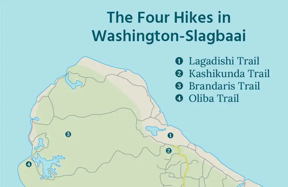

During a day in the national park, you immerse yourself in Bonaire’s stunning natural beauty. Even more so if you decide to explore one of Washington-Slagbaai’s four hiking trails. Stepping out of the car allows you to experience nature much more intensely and offers views hidden from other visitors. Start your day with the Lagadishi, Kashikunda, or Brandaris Trail, or end it with the Oliba Trail.
Sharing Island Love
Thank you for your interest in our beautiful island in the Caribbean! We love sharing our passion for Bonaire with everyone — locals, visitors, and of course, with our guests during Our tours. Curious how we do that? You can find all the details in Sharing Island Love.
With Island Love,![]()
Fortunately, we’re not limited to the national park for nature walks on Bonaire. Be sure to check out our blog on The ten best hikes outside Washington-Slagbaai.
Onderwerpen
Preparation
The park opens at 8 AM, and by then it’s already getting quite warm. If you plan to start your day with a hike in Washington-Slagbaai, it’s best to arrive right when the gates open. Be sure to check out our handy hiking tips and learn about the Nature on Bonaire. If you do find yourself in trouble, call the STINAPA emergency number: +599 777 8444.
Would you prefer to explore with an experienced guide, or learn more about the park’s nature, history, and geology along the way? Book a Customized hiking tour with us, or book the Washington-Slagbaai tour, a fully guided day trip that we love to kick off with a scenic hike! Just like our other tours, by the way!
Text continues below…

Explanation of trails and rating
Three types of trails:

Difficulty rating:
* Walk on accessible, flat terrain.
** Walk on accessible, gently sloping terrain or uneven ground.
*** Walk on sloping terrain.
**** Walk on sloping terrain, with occasional short climbs.
***** Challenging walk on steep terrain, requiring frequent climbing.
The length of the walk is not taken into account when determining the difficulty level.
Lagadishi Trail (1)

At the entrance to Washington-Slagbaai National Park, you find the Lagadishi Hike. This beautiful and varied walk takes you across a stunning coastal plain. Along the way, you pass dramatic cliff shores and visit the Lagadishi Blowhole. You also encounter Playa Chikitu, a beach on the east coast with unique sand dunes where turtles nest. The trail continues through a mangrove area and leads to Saliña Matijs, offering a fantastic view of flamingos.

Practical information:
Difficulty: **
Length: 4 km (2.5 miles), loop trail
Parking along a paved road, starting point a bit further down.
Can be combined with: A visit to Washington-Slagbaai
The Lagadishi Hike is relatively long and offers little shade, something to keep in mind! Park at the designated area outside the park. Inform the ranger at the office that you’re here to hike. After showing your STINAPA Nature Tag and ID, you can walk into the park. About 300 meters (1000 feet) in, turn right to start the Lagadishi Hike. The trail is marked with yellow posts. While the terrain is flat, the uneven ground requires a bit of hopping, skipping, and jumping!

Tiko, the white donkey
Donkeys are not allowed in the National Park. However, during the Lagadishi Hike, you may encounter one. Tiko is the smartest donkey on Bonaire and knows better than anyone how to sneak into the park. He patiently waits at the gate, watching from a distance for his chance. When the rangers aren’t paying attention, he trots into the park. Once he has his fill, he casually strolls back to the exit, where he is quickly shooed out.
Do you enjoy stories like this? Then join us and book a tour!
Kashikunda Trail (2)

Also starting near the park entrance, the Kashikunda Trail takes you to the top of the 94-meter/300-feet-high Kashikunda. This hill is part of Bonaire’s ancient foundation, emerging from the sea 60 to 70 million years ago. Before the climb, it’s worth exploring The geology of Bonaire to fully appreciate the experience. The climb itself is a challenging but rewarding adventure, offering breathtaking views and an incredible panorama from the top!

Practical information:
Difficulty: *****
Length: 2 km (1.25 miles), loop trail
Parking along a paved road, starting point a bit further down.
Can be combined with: A visit to Washington-Slagbaai
Park outside the entrance and inform the ranger that you’re hiking. After showing your STINAPA Nature Tag and ID, turn left behind the museum. The trail begins 200 meters ahead on the right and is clearly marked with yellow posts and stones.
The Kashikunda Trail is highly demanding. Most of the trail requires stepping from rock to rock. During the final climb and descent, you often need to use your hands for bouldering. Be cautious of slippery rocks, especially after rain. If conditions are wet, the Lagadishi Hike may be a safer choice. Also, watch out for the numerous cacti and thorny bushes along the path.
Text continues below…

Brandaris Trail (3)

At 241 meters (790 feet), the Brandaris is the highest point on Bonaire. The hike to the top is intense and adventurous, but the breathtaking views along the way and at the summit make it well worth the effort. The first part of the trail ascends gradually, offering your first scenic outlooks early on. After that, the real climbing begins, but you don’t need to complete the hike to enjoy spectacular views.

Practical information:
Difficulty: *****
Length: 4 km (2.5 miles), out-and-back trail
Starting point along an unpaved road.
Can be combined with: The short route through Washington-Slagbaai
Steep cliffs, large boulders to scramble over, and little to no shade along the way—there are plenty of challenges to overcome before reaching the summit of the Brandaris. The trailhead is located along the short route through Washington-Slagbaai National Park. That’s about a 30-minute drive from the entrance, where you need to show your STINAPA Nature Tag and ID. Since the park opens at 8 AM, you will likely start the hike around 8:30 AM. By then, temperatures will already be rising, so be sure to bring plenty of water. We recommend avoiding this hike on calm or rainy days.
Oliba Trail (4)

The Oliba Trail is the newest hike in Washington-Slagbaai National Park. It is named after the local olive tree, which you will encounter frequently along the route. The hike takes you through the park’s first goat-free zone, where young trees are given a chance to grow. It’s a fun and varied hike, starting with a stunning view over Saliña Slagbaai and then winding through the heart of the inland terrain. The trail ends on the southern cliff of the Slagbaai, offering a beautiful view of the bay, the plantations, and the saliña.
The Slagbaai is one of the final stops along the route through Washington-Slagbaai, making the Oliba Trail the perfect hike to finish your day. Note: Make sure to be back at your car before 4:00 PM, as visitors are expected to head to the exit by then.

Practical information:
Difficulty: ***
Length: 1.5 km (1 mile), loop trail
Parking along an unpaved road.
Can be combined with: A visit to Washington-Slagbaai
If you want to hike the Oliba Trail, park your car at one of the parking lots on the south side of Slagbaai. The hike starts a little further along, towards the exit. Just follow the blue stones along the road. The hike mostly takes you over flat terrain, but starts with a steep climb to the viewpoint at 42 meters (140 feet). The difficulty also depends on the time of day you choose to do this hike. Most visitors to the park reach Slagbaai around noon when the sun is at its hottest, so be sure to bring plenty of water!
Text continues below…

About us: A tour with HopiBonaire
A tour with HopiBonaire is so much more than just a drive. Join us on an exploration of the island, visiting not only the famous highlights but also the many hidden gems Bonaire has to offer. Of course, a beautiful hike is a must! Even if you’re not a hiker, you’re in the right place with us. We tailor the program as much as possible to your preferences and interests. During the tour, you set the pace. Only then can you fully enjoy all the beauty the island has to offer!
Read more?