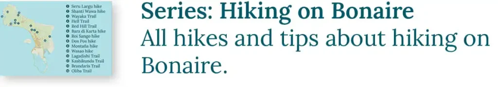
Are you passionate about hiking and have you already completed the 10 well-known hiking trails on Bonaire? Then this is for you! The Chantiwawa Trails hiking group proudly presents five new hiking routes on Bonaire. Setting out, clearing, and marking these trails has been a huge effort for them, so we are honored to share these spectacular routes with you. Hike straight through Bonaire’s nature, past breathtaking viewpoints, abandoned ruins, and monumental trees, and support the preservation of these beautiful routes simply by hiking them!
Sharing Island Love
Thank you for your interest in our beautiful island in the Caribbean! We love sharing our passion for Bonaire with everyone — locals, visitors, and of course, with our guests during Our tours. Curious how we do that? You can find all the details in Sharing Island Love.
With Island Love,![]()
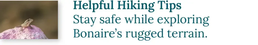
With proper preparation, you can enjoy all these hikes independently. Be sure to check out our helpful hiking tips and learn about the Nature on Bonaire. Want to make the most of your walk? Book a customized hiking tour with us. Immerse yourself in fascinating nature, uncover traces of the past, and return home with stunning photos. And since we only offer private tours, you can walk at your own pace and without a care in the world!
Explanation of trails and rating
Three types of trails:

Difficulty rating:
* Walk on accessible, flat terrain.
** Walk on accessible, gently sloping terrain or uneven ground.
*** Walk on sloping terrain.
**** Walk on sloping terrain, with occasional short climbs.
***** Challenging walk on steep terrain, requiring frequent climbing.
The length of the walk is not taken into account when determining the difficulty level.
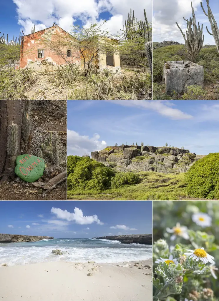
Ruta Burubari

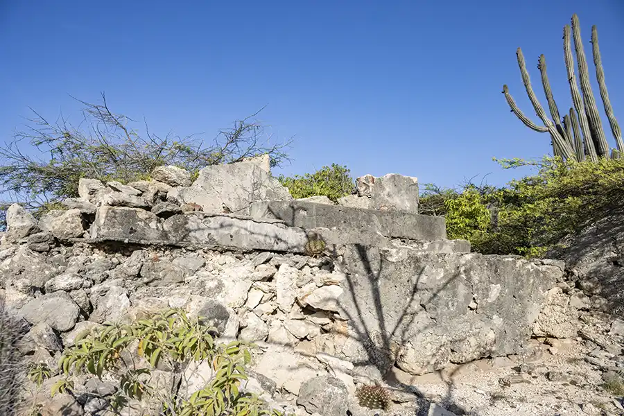
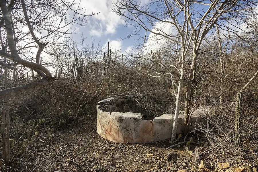
Ruta Burubari is a tree-rich trail located in the heart of the island. The hike starts at the dilapidated overseer’s house and old goat corral of Plantation Colombia. The route is named after the Burubari tree, but along the way you will encounter many other impressive tree species and cacti. In the early morning and late afternoon, the area comes alive with the sound of birdsong. The path winds gradually toward an impressive cliff, which you can even climb at the marked point. At the top, you will be rewarded with a sweeping view over the East Coast of Bonaire.
Practical information
Difficulty: **
Length: 3.5 km (2.2 miles), out-and-back trail, with a substantial loop
Starting point along a paved road.
Can be combined with: Ruta Dos Laman (Hell Trail) and the Wayaka Trail
This very accessible route starts at Porta Spaño, along the old, deteriorated road to Rincon. After 150 meters (500 feet) on this road, you will see the old goat corral and the remains of the overseer’s house of Plantation Colombia on your right. Definitely worth a stop!
The actual hike begins a bit further on, after you pass a limestone excavation on your left. At the painted stone marked “Ruta Burubari,” turn left and follow the trail marked with blue and red paint. After about 500 meters (a third of a mile), you will reach a small bench under a Wayaka tree. Here begins the loop trail, which is best walked clockwise. Midway, you will come to the cliff that leads up to the viewpoint. The climb to the top of the cliff is challenging.
For experienced hikers, a 300-meter (1000 feet) shortcut has been created at the top of the cliff, connecting to this point on the Ruta Dos Laman (Hell Trail). This section is rougher, more densely vegetated, and less clearly marked with red paint. Bringing pruning shears is recommended.
Ruta Onima
Ruta Onima is a versatile route on the former Plantation Onima. The hike goes around one of the most photogenic hills on Bonaire, the Kaomati. Along the way you come across remains from the plantation era, such as an overseer’s house, an old water well and several aloe ovens.

On the plantation rainwater was retained by several dams. During the rainy season you cannot do this hike, because a lake forms between the dams. In the dry season this lake dries up again and the route leads across the fertile soil. On this soil thousands of melons, pumpkins and local cucumbers were grown in the past, which were then exported to Curaçao.
After you have crossed the lake, you walk clockwise around the Kaomati. The path winds gently along the large chunks of limestone that have rolled from the hill. In the north you leave the hill behind and walk toward the rugged east coast. Via the impressive Boka Onima you reach the Onima Rock Art. There you find a narrow path that runs over a cactus covered terrace back to the starting point of the route.
Climbing the Kaomati
This route goes around the Kaomati, but on top of the Kaomati you can enjoy one of Bonaire’s most beautiful views. It is a challenging climb that can only be done safely with an experienced local or with us during a guided hiking tour.

Practical information
Difficulty: ****
Length: 3 km (2 mi), loop trail with the option to shorten the route.
Starting point along a paved road.
Note:
In the rainy season and the months after this route sometimes cannot be hiked because it is partly under water.
The route starts at the bend toward Rincon, on the main road between Kralendijk and Rincon. There you can park your car. Cross carefully, people drive fast here. On the other side of the road you find the green stone with “Ruta Onima” on it (Google Maps). From there you follow the orange stones. Along the way you will also see red and pink markers which you can ignore.
First the orange markers lead you to the Onima overseer’s house and then to an open plain that sometimes floods. For that reason, that section is not marked. Cross the plain to the far left back corner. There, at the overflow of the first dam (Google Maps), the orange marking starts again.
Do you want to shorten the route?
Do not walk to the overflow of the first dam but turn right on the plain. After passing the second and the third dam you arrive at Boka Onima.
From the overflow the route winds toward the back of the Kaomati. There you climb to a section of middle terrace with hundreds of melon cacti. In front of you you enjoy a wide view over the east coast and behind you of the Kaomati. The orange stones lead you to the dirt road between Boka Onima and Morotin. Turn right onto this road. The orange markers stop here.
After Boka Onima you follow the dirt road to the right until you reach the cliff with the Onima rock art. There, behind you, you find a small path where the orange marking starts again. Follow the orange stones to a second location with rock art and then climb the middle terrace. On this terrace you find a decayed aloe oven. After that the orange route descends again to the parking area.
Download the reminder:
Fortunately you do not have to remember all of this. Download the reminder on your phone here.
Ruta Colá
Ruta Colá is a beautiful hike full of panoramic views that connects to the Seru Largu Trail. You walk along distinctive vegetation, such as the Monkey puzzle euphorbia (Káktùs Sürnam in Papiamentu), the green saddle tree (Palu di sia bèrdè), the brazilwood tree (Brasil) and hundreds of melon cactuses (Bushi). The route can easily be extended and is therefore suitable for every hiker.
Practical information
Difficulty: ****
Length: 0,8 km (0.5 mi), Point to point
Tip: 3-4 km (2-2.5 mi), loop trail combined with the Seru Largu Trail!
Starting point along a paved road.
Can be combined with: the Seru Largu Hike or the Chanti Wawa Trail.
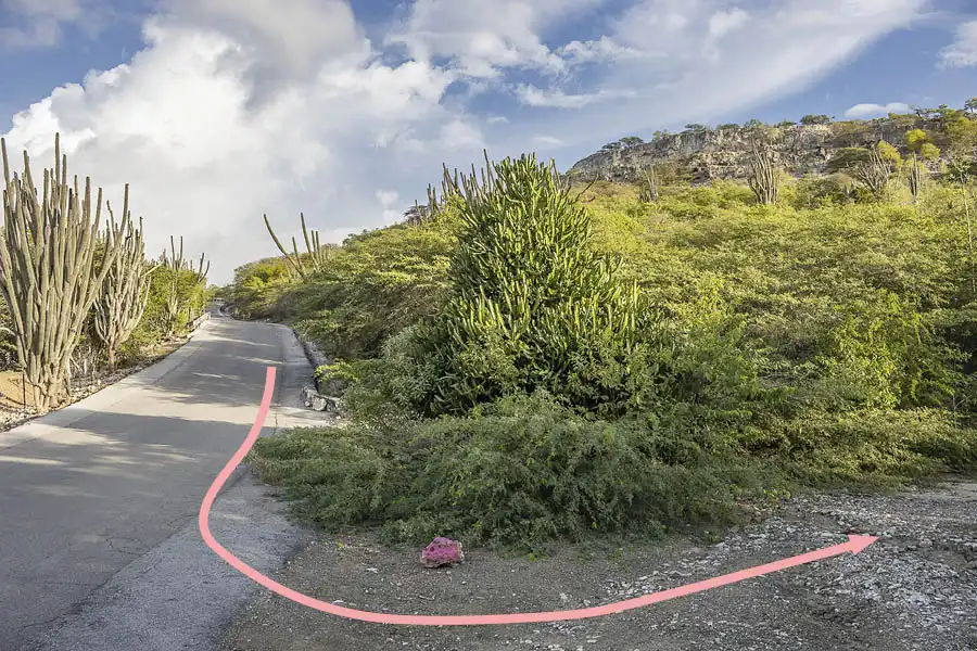
Here we describe the loop trail of 3 to 4 kilometers (2-2.5 mi) along and over the Seru Largu. Park at Cruz Seru Largu (Google Maps) and walk from there along the asphalt road toward Kralendijk. After the steepest part is behind you, you find a large Monkey puzzle euphorbia (the “Christmas tree”) on the left side of the road. That is where Ruta Colá starts (Google Maps), marked with pink stones.
The route runs at the foot of the Seru Largu but climbs at the end to the Seru Largu Trail, which is marked with softer pink stones. If you turn left on this trail you walk a total of 3 kilometers (2 mi). If you turn right you walk one kilometer (0.6 mi) extra. You end up at the parking area either way.
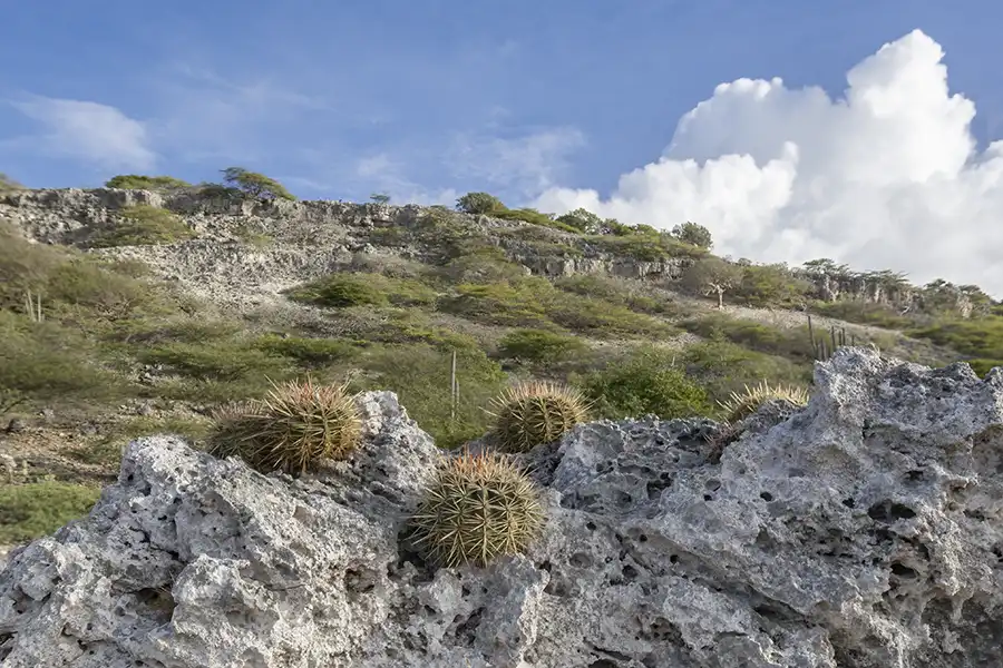
Ruta Nene Shòrs

Ruta Nene Shòrs is a hike over a hill and down into a valley that was once the domain of Cornelis George, nicknamed “Nene Shòrs”. He kept a hòfi (small garden plot) here with goats, sheep, and fruit trees, including medlar trees. Of the original hofi, the well is all that remains today. We would like to thank the George Family for opening up this special area to the public!
The trail passes an old dam and remarkable quartz rock formations. After about 400 meters (a quarter mile), you reach a scrambling rock with stunning views over the southern part of Bonaire. The route ends at the highlight of the trail: Pos Nene Shòrs. At an impressive depth of 14 meters (46 feet), this is the deepest hand-dug well on Bonaire.
Practical information
Difficulty: ***
Length: 2,5 km (1.5 mi), Out and back
Starting point along a unpaved road.
Can be combined with: Ruta Joselito Oleana on Seru Grandi
Drive past Kunuku Mexico and follow the public road. Where the road narrows, park at the gate of a local plot (Google Maps). Parking is limited, keep the entrance clear. The narrower path is marked with purple and blue stones. After about 300 meters (0.2 miles), turn left and follow the purple stones to the well. Return via the same path.
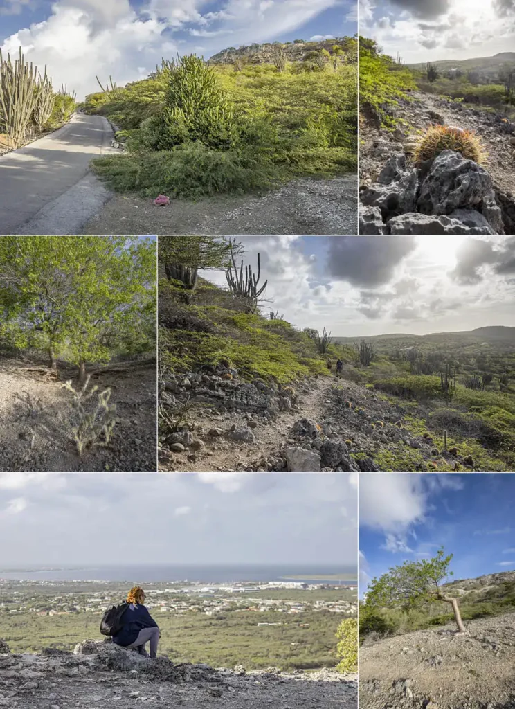
Ruta Joselito Oleana | Seru Grandi

De Seru Grandi near Kralendijk
Just like the much better known Seru Largu, Seru Grandi is also a hill just outside Kralendijk. Seru Largu is known for its beautiful view over Kralendijk and the southern tip of the island. Seru Grandi is far less known, because its steep peaks were barely accessible for a long time. Not anymore! Chantiwawa Trails has built a well maintained path, and the view from the peaks of Seru Grandi turns out to be even wider than the view from Seru Largu.
Inside the national park, you will find a well known cliff that is also called Seru Grandi. You can read all about it in our Blog about Washington-Slagbaai.
Ruta Joselito Oleana begins at Pos Fortuna, a well more than eighty years old. From there, the path winds in a wide curve toward the southwestern peak, and during the climb you can already enjoy several vistas. At the first cadastral pillar, at a height of 100 meters (328 feet), you are rewarded with the first sweeping view, from Washikemba to Klein Bonaire.

After this peak, the route descends slightly, offering a view of the wooded valley between the northern and southern parts of Seru Grandi. A second climb takes you to the northwestern peak, again at 100 meters (330 feet) high. From there you look out from Lac Bay to Playa (the center of Kralendijk), and you can also see Seru Largu.
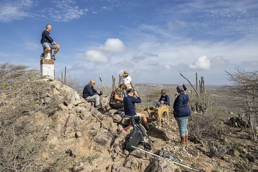
From here, the route climbs steadily onward to the absolute high point of the hike: the cadastral pilllar on the northeastern peak, at 115 meters (375 feet). Here you are overwhelmed by a panoramic view, from coast to coast.
As a final treat, the descent takes you past a monumental wamari tree, a beautiful, quiet ending to this impressive route.
Joselito Oleana
The route on Seru Grandi is named after Joselito Oleana, in memory of this dedicated member of Chantiwawa Trails. He spent countless hours here, out of pure love for this area. It is therefore a fitting tribute that this route now carries his name. The route was opened on July 18, 2026, in the presence of his family and with a large turnout of everyone who knew him.
Practical information
Difficulty: ****
Length: 2,75 km (1.7 mi), Loop trail
Starting point along a unpaved road.
Can be combined with: Ruta Nene Shòrs
You will find the starting point 400 meters (a quarter mile) behind Kunuku Mexico,after a drive of about two kilometers (1.2 miles) over unpaved roads. Park the car next to Pos Fortuna. The route is marked with pink/blue markers. During the climb to the southwestern and northwestern peaks, alternative, steeper routes have been laid out for those looking for more of a challenge. These are marked with a dark blue stone. 750 meters (0.5 mi) after the highest peak, you reach a wide path. From there you can connect to Ruta Nene Shòrs (2.5 km/1.5 mi), or finish Ruta Joselito Oleana by walking 700 meters (0.5 mi) back to the parking area at Pos Fortuna.

Download the reminder:
Fortunately you do not have to remember all of this. Download the reminder on your phone here.
Read more?